Garces' Mojave Crossing
Father Garcés made five journeys during the 13 years he lived at San Xavier del Bac. The first two trips were missionary journeys intended to convert the Indians to Christianity. On these trips he went only as far as the Gila River.
On the third trip made by Father Garcés, he was looking for places where new missions could be built. It was on this trip in 1771 that he first entered Alta (Upper) California. Again he went from San Xavier to the Gila River and then followed the Gila River downstream.
Garcés was looking for the Colorado River. However, rains had swollen the waters of the Gila so much that he did not realize when the Gila joined with the Colorado. Thinking he had missed the junction with the Colorado River, he crossed the river and started west across the desert. He was now in Alta California. His Indian guide soon left him and Garcés decided to turn back. He had, however, gotten far enough to see mountains to the west, and the passes through them.
In 1774 Captain Juan Bautista de Anza was given permission to try to find an overland route from Mexico to California. It was the report Garcés had made of his 1771 trip that convinced Anza that such a route was possible. Now he engaged Garcés to guide his expedition across the Colorado River and into the California desert.
Garcés took Anza as far as he himself had gone in 1771. With them also was Sebastián Tarabal, an Indian guide who helped Anza find a route on to Mission San Gabriel in the Los Angeles valley.
When Anza made his second trip in 1775 with a group of 240 settlers heading for Monterey and San Francisco, Garcés again went with him as far as the Colorado River. This time Garcés stayed near the Colorado River to do some more exploring on his own.
Early in 1776 Garcés set out northward once again from the Colorado River. He crossed the Mohave Desert and the San Bernardino Mountains, probably through what is now Cajon Pass, and reached Mission San Gabriel. This route was called the Mohave Trail. Then he kept going north over the Tehachapi Mountains into the San Joaquin Valley. His goal was to reach the mission at San Luis Obispo, close to the central California coast.
Just a few days walk short of the coast, Garcés decided to turn back. He again crossed the mountains, the desert, and the Colorado River, heading east this time, and went on into northern Arizona where the Hopi Indians lived. His plan was to go as far as the Zuni Indian villages in New Mexico, but the unfriendliness of the Hopis made him change his mind.
Social Studies Fact Cards, "FRANCISCO GARCES," http://factcards.califa.org/exp/garces.html (accessed - 1/5/2018)
excerpts from:
On the Trail of a Spanish Pioneer
By Francisco Tomás Hermenegildo Garcés, Elliott CouesChapter VI.*
From Mojave to San Gabriel
- 234 - Garces leaves the Mohave villages and begins his journey.Pozos de San Caimiro
- 235 - I departed, accompanied by three Jamajab Indians and by Sevastian, on a course ...Sierra de Santa Coleta
- 236 - Departing by the northwest I traveled eight leagues west one quarter westsouthwest, ...Canada de Santa Tomas
- 237 - In the afternoon I passed the sierra through a good gap, and at the outlet ...Sierra Pinta-Arroyo de Los Martires
- 238 - Here I encountered an arroyo of saltish water that I named ...Discovery of the Mojave River
- 239 - ... I arrived at some rancherias so poor that they had to eat ...Beneme Indians San Jose Noted
- 240 - Here grows the wild grape; there is much grass; also mezquites and trees that ...Continuing Up the Mojave River
- 241 - ... and they hear with attention that which is told them of God.Past Old Camp Cady
- 242 - ... this Godforsaken Botany Bay of a place, the meanest I ever saw yet ...Another Beneme Rancheria
- 243 - Sevastian returned without mishap, praising the kind reception that had been given ...Politeness of these Poor Indians
- 244 - Likewise when the second woman came she expressed her affection by ...Leaving the River by a Canada
- 245 - On my arrival (quando iba llegando) some howled like wolves, ...Over the Sierra
- 246 - I saw many cottonwoods, alders, oaks, very tall firs, and beautiful junipers ...Upon the Road of the Expedition
- 247 - At a little distance from its foot I found another rancheria where the Indians ...Arrival at the San Gabriel Mission
- 248 - ... I was received by the padres with great kindness, ...About this map
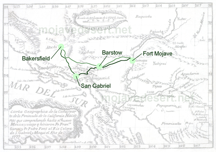
The route of Garces is shown as an overlay on an important map showing the complete routeof the remarkable journey of Fr. Francisco Garces (1738-1781) through portions of southwestern Arizona and southeastern California, along the Colorado River, and into the southern San Joaquin Valley, back across the Mojave to the Mojave Indian villages and then to the Hopi town of Oraibi in northeastern Arizona. The journey lasted from October 1775 to September 1777.
The cartographer of this map is not known; however, the possibility exists that it may have been Fr. Pedro Font (d. 1781) who is known to have prepared several excellent maps. The map was engraved by Manuel Villavico, and it has been suggested that this engraving was intended to illustrate a book that was never published, hence its great rarity.
Editor's Notes:
The first 5 chapters have been omitted in order to start with Fr, Garces' journey across the Mojave as the chapters beyond and parts of chapter 7. These will be added and listed here as well as in other section as they become available.
The page and numbering format have been kept to individual web pages as in the original volume. Doing so keeps Elliott Coues' notes in order without having to renumber or edit them.
Text from Garces' journal is shaded while Eliott Coues' copious notes are left with a clear white background. My notes, photos and related page links are along the right of the page, or, in some cases, at the bottom below the text.
A league is the approximate distance a man or mule can walk in an hour. This converts to somewhere between 3-5.5 miles
Pronunciation of the letter "J", is Spanish with an "H" sound. The word for the Mohave Indians in this text is "Jamajab", which properly pronounced sounds like; Hamahab, which sounds like Aha Macav, the Mohave name for themselves.
Other Indian names which may at first appear confusing are:
-
Beneme = Vanyume (a branch of the Serrano/Yaharetum)
Chemebet = Chemehuevi (a branch of the Southern Paiute)
Yabipais Tejua = Yavapai
Jaguallapai = Hualapai
Jalchedunes = Halchidoma