Water Trails of the Ceriso
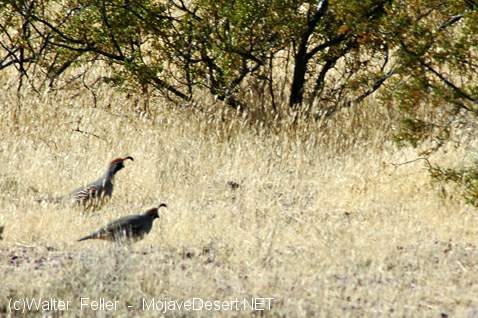
The crested quail that troop in the Ceriso are the happiest frequenters of the water trails. There is no furtiveness about their morning drink. About the time the burrowers and all that feed upon them are addressing themselves to sleep, great flocks pour down the trails with that peculiar melting motion of moving quail, twittering, shoving, and shouldering. They splatter into the shallows, drink daintily, shake out small showers over their perfect coats, and melt away again into the scrub, preening and pranking, with soft contented noises.
After the quail, sparrows and ground-inhabiting birds bathe with the utmost frankness and a great deal of splutter; and here in the heart of noon hawks resort, sitting panting, with wings aslant, and a truce to all hostilities because of the heat. One summer there came a road-runner up from the lower valley, peeking and prying, and he had never any patience with the water baths of the sparrows. His own ablutions were performed in the clean, hopeful dust of the chaparral; and whenever he happened on their morning splatterings, he would depress his glossy crest, slant his shining tail to the level of his body, until he looked most like some bright venomous snake, daunting them with shrill abuse and feint of battle. Then suddenly he would go tilting and balancing down the gully in fine disdain, only to return in a day or two to make sure the foolish bodies were still at it.
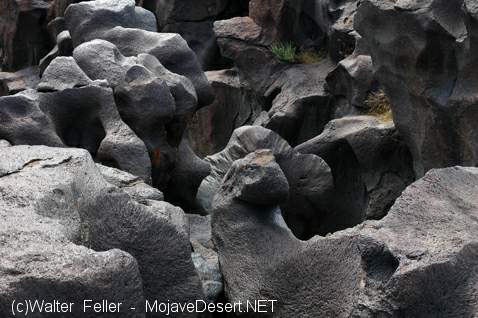
Out on the Ceriso about five miles, and wholly out of sight of it, near where the immemorial foot trail goes up from Saline Flat toward Black Mountain, is a water sign worth turning out of the trail to see. It is a laid circle of stones large enough not to be disturbed by any ordinary hap, with an opening flanked by two parallel rows of similar stones, between which were an arrow placed, touching the opposite rim of the circle, thus it would point as the crow flies to the spring. It is the old, indubitable water mark of the Shoshones. One still finds it in the desert ranges in Salt Wells and Mesquite valleys, and along the slopes of Waban. On the other side of Ceriso, where the black rock begins, about a mile from the spring, is the work of an older, forgotten people. The rock hereabout is all volcanic, fracturing with a crystalline whitish surface, but weathered outside to furnace blackness. Around the spring, where must have been a gathering place of the tribes, it is scored over with strange pictures and symbols that have no meaning to the Indians of the present day; but out where the rock begins, there is carved into the white heart of it a pointing arrow over the symbol for distance and a circle full of wavy lines reading thus: "In this direction three [units of measurement unknown] is a spring of sweet water; look for it."
< Previous - Next >